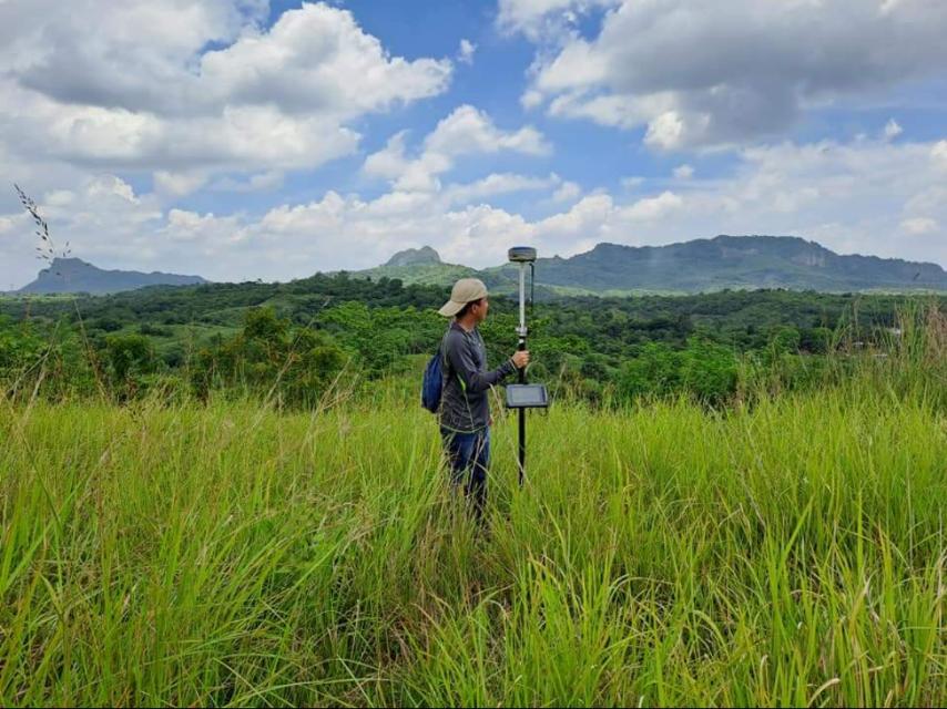
A Relocation Survey and Monumenting is one of the most common and essential land surveying services in the Philippines. It verifies the exact location and boundaries of a property by retracing its original survey data, technical descriptions, and land titles. After confirming the correct boundaries, surveyors establish or restore physical monuments (markers) on the ground to clearly indicate property lines.
This service is crucial for property owners, developers, and legal entities because land disputes, encroachments, and boundary errors can lead to costly conflicts. At MLL III Land Surveying and Mapping Services, we provide accurate, legally compliant, and certified relocation surveys that protect ownership rights and ensure clarity of property limits.
Services
Relocation surveys are often required in the following situations:
Property Sales or Transfers: Buyers and sellers need to ensure that the land being transferred matches its title and technical description.
Construction Projects: Before building, landowners must confirm boundaries to avoid encroaching on neighboring lots.
Boundary Disputes: Conflicting claims between neighbors or within families can be resolved through certified relocation surveys.
Land Titling and Subdivision: Government agencies often require relocation surveys to approve applications for new or revised land titles.
Verification of Lot Ownership: Heirs and landowners may need to re-establish monuments when older markers have disappeared or been destroyed.
Without a relocation survey, property owners risk boundary overlaps, encroachment lawsuits, and legal delays.
Services
At MLL III, relocation surveys follow a standardized and compliant process to ensure accuracy and legality:
Initial Consultation – We collect details of the land, including titles, technical descriptions, and any existing surveys.
Research and Verification – Our licensed geodetic engineers review government records, maps, and previous surveys from DENR, LRA, and LGUs.
Field Survey and Measurements – Using GNSS, Total Stations, and reference points, we determine the exact coordinates of the property boundaries.
Boundary Verification – Lines are measured and compared against technical descriptions to identify discrepancies or encroachments.
Monument Installation – We establish or restore concrete boundary markers (PS or BLLM monuments) at key corners of the property.
Data Processing and Validation – Survey results are checked against official benchmarks to ensure legal compliance.
Survey Outputs – We provide certified survey plans, technical descriptions, and maps, sealed by a licensed geodetic engineer.
Services
For Property Owners: Protects legal rights by confirming boundaries and preventing disputes.
For Buyers and Sellers: Ensures land being sold matches official records, reducing risks in real estate transactions.
For Developers: Prevents costly delays and conflicts before construction begins.
For Government Agencies: Provides legally admissible data for titling, registration, and subdivision approval.
At MLL III, we strictly comply with the Geodetic Engineering Act of 1998 (RA 8560) and relevant regulations of the DENR, LRA, HLURB, and LGUs. Our relocation surveys are performed and certified by licensed geodetic engineers registered under the Professional Regulation Commission (PRC). This ensures that results are legally valid, court-admissible, and acceptable for government processing.
To deliver accuracy and efficiency, we use:
GNSS positioning systems for high-precision georeferencing
Total Stations for exact distance and angle measurements
UAVs (Drones) for aerial verification and mapping (if required)
AutoCAD Civil 3D and GIS software for plotting, validation, and documentation
These technologies allow us to provide quick turnaround times while maintaining the strict accuracy required by law.
Residential Properties: Homeowners use relocation surveys to confirm fences and house placement before construction.
Subdivision Development: Developers verify property lines before subdividing land into saleable lots.
Agricultural Land: Farmers establish clear field boundaries to avoid disputes with adjacent landowners.
Commercial and Industrial Projects: Ensures warehouses, factories, and business structures are built within the legal property limits.
Inheritance and Estate Division: Families use relocation surveys to legally partition land among heirs.
Get in touch with us for accurate and reliable surveying and mapping services in the Philippines. Contact us for a consultation and let us guide your project with precision and expertise.
This website uses cookies to provide you with the best browsing experience.