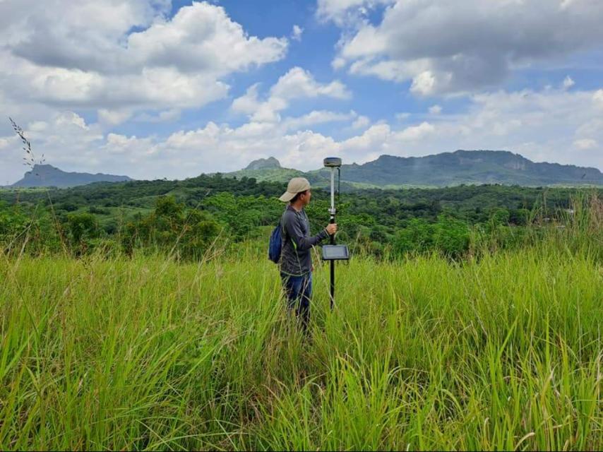
Lot Subdivision and Partitioning

Introduction

Lot Subdivision and Partitioning is a land surveying service that divides a single parcel of land into smaller, distinct lots with their own boundaries and technical descriptions. It is often used for inheritance purposes, land sales, or property transfers. By creating new legal parcels, subdivision and partitioning make land easier to manage, distribute, and sell.

At MLL III Land Surveying and Mapping Services, we provide accurate and legally compliant subdivision surveys that follow Philippine regulations. Whether you are dividing land among family members, preparing property for sale, or restructuring lots for titling, our licensed geodetic engineers ensure that the process is precise, efficient, and fully recognized by government agencies.

Services

Why Lot Subdivision and Partitioning is Needed

Lot subdivision and partitioning is commonly required in these scenarios:

  • Inheritance Distribution: Families dividing land among heirs need official subdivision plans to avoid disputes and secure individual titles.

  • Property Sales: Landowners may split a large property into smaller lots to increase market value and make it easier to sell.

  • Business and Development Projects: Developers may partition land to prepare it for residential, commercial, or mixed-use projects.

  • Legal and Government Compliance: Subdivision and partitioning are often prerequisites for titling, tax declarations, and land registration.

  • Dispute Settlement: Partition surveys can resolve conflicts by providing clear, documented boundaries for each owner’s share.

Without proper subdivision and partitioning, ownership transfers can face delays, legal challenges, or rejection by government offices.

Services

The Process of Lot Subdivision and Partitioning

At MLL III, we follow a structured process to ensure accuracy and government compliance:

  1. Initial Consultation – We gather details about the land, ownership documents, and the intended division.

  2. Research and Verification – Our team verifies land titles, tax declarations, and existing survey records with DENR and LRA.

  3. Field Survey and Measurement – Using GNSS and total stations, we measure boundaries and establish the subdivision layout.

  4. Subdivision Design – The land is divided into lots according to client requirements, inheritance agreements, or development goals.

  5. Monumenting – Physical monuments or markers are installed to indicate the new lot corners.

  6. Documentation – Subdivision and partition plans are prepared, plotted in AutoCAD Civil 3D/GIS, and reviewed for accuracy.

  7. Approval and Certification – Plans are submitted to LGUs, DENR, or DHSUD as required. A licensed geodetic engineer certifies all outputs.

  8. Final Deliverables – Clients receive approved subdivision maps, technical descriptions, and digital files for titling and registration.

Services

Benefits of Lot Subdivision and Partitioning

  • For Families: Provides a fair, legal, and documented way to divide inherited property among heirs.

  • For Property Owners: Increases land value by creating smaller, marketable lots.

  • For Developers: Prepares land for housing or commercial development with legally approved subdivisions.

  • For Buyers: Guarantees that purchased lots are clearly defined and registered.

  • For Government Agencies: Ensures land use and subdivision are compliant with zoning and regulatory standards.

Compliance and Accuracy

Our subdivision and partitioning services comply with the Geodetic Engineering Act of 1998 (RA 8560) and the technical requirements of DENR, HLURB/DHSUD, LGUs, and LRA. All plans are prepared and certified by PRC-licensed geodetic engineers, ensuring legal validity for land titling, estate settlement, and property transfer.

Technology in Use

We use advanced tools and software to carry out accurate subdivision surveys:

  • GNSS positioning systems for boundary precision

  • Total Stations for exact measurements

  • Drones/UAVs for aerial verification and mapping (if needed)

  • Civil 3D, AutoCAD, and GIS platforms for subdivision design and plotting

This technology ensures accuracy, faster processing, and full compliance with Philippine surveying standards.

Real-World Applications

  • Estate Division: Families dividing inherited land among children or heirs use subdivision plans to secure individual titles.

  • Property Development: Developers prepare large parcels of land by partitioning them into smaller, legally recognized lots.

  • Agricultural Land: Farmers may divide farmland for separate ownership or sale.

  • Commercial Resale: Landowners increase profit potential by subdividing property into smaller parcels that attract more buyers.

  • Legal Settlements: Partition surveys provide official documentation to resolve disputes over land ownership or boundary claims.

Start Your Project with Confidence Today!

Get in touch with us for accurate and reliable surveying and mapping services in the Philippines. Contact us for a consultation and let us guide your project with precision and expertise.

This website uses cookies to provide you with the best browsing experience.

Accept
Decline